Amelia Aerospace · CorridorOS
Infrastructure Tooling for Air Corridor Planning & U-space Compliance
CorridorOS is a pre-tactical planning and governance platform that helps competent authorities, cities, and hospitals design, allocate, and monitor low-altitude air corridors in a way that is consistent with EU U-space and SESAR concepts. The deployment of this governance layer is essential for achieving the Single European Sky objectives for AAM. The focus is on compliant, predictable operations and clear non-duplication of regulatory functions.
A product of Amelia Aerospace Company.
Who it’s for
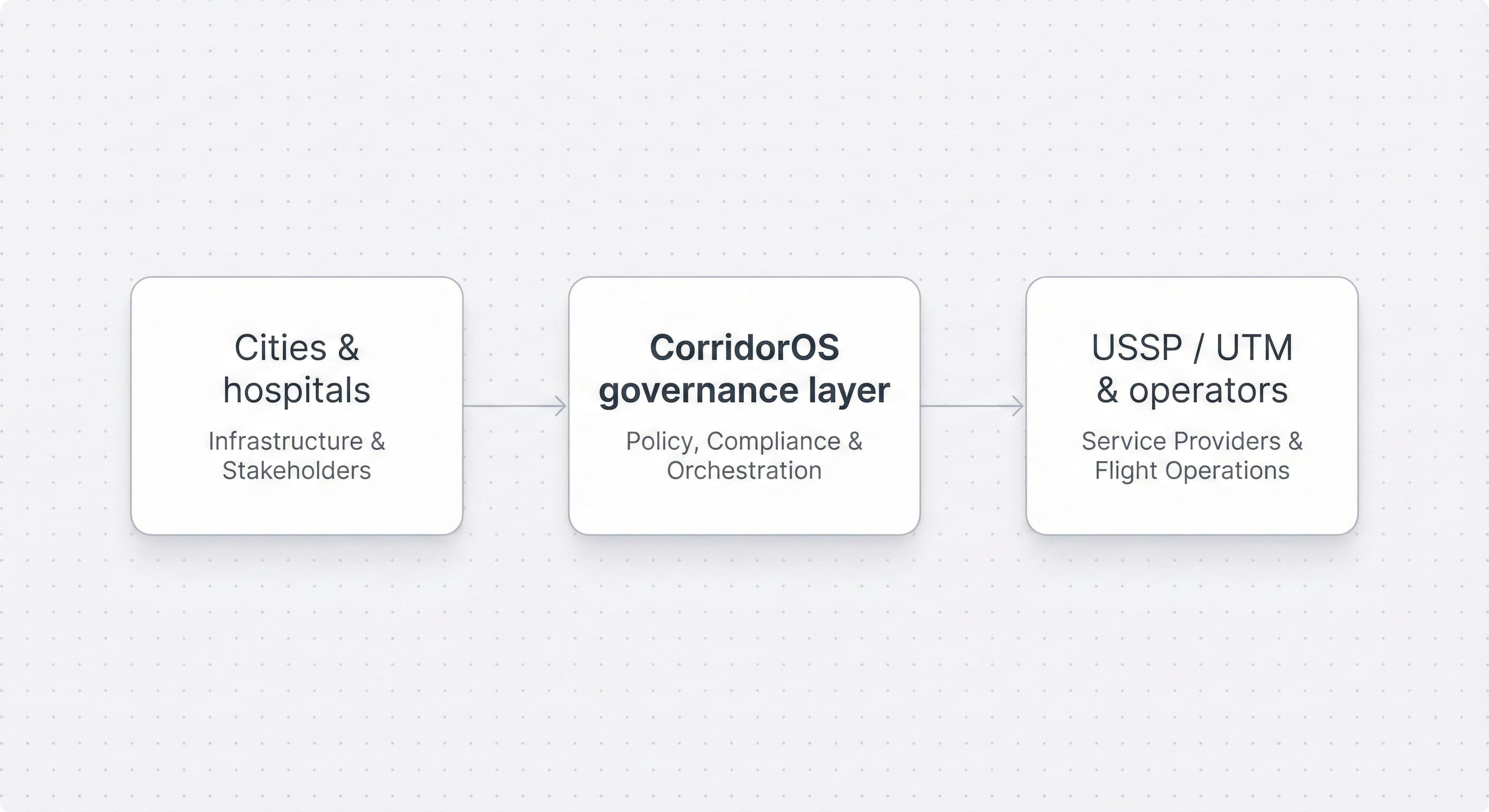
CorridorOS sits at the intersection of aviation supervision, municipal governance, and healthcare operations. It provides a shared corridor picture while keeping regulatory authority with the competent bodies.
Civil aviation authorities & ANSPs
A digital architect tool to intake, validate, and standardize local corridor data, reducing the administrative burden of U-space coordination (Art. 18(f)).
Cities & regional authorities
Tools to express local policy, noise, and ESG constraints in a way that can be consumed by U-space service providers and operators.
Hospitals & critical infrastructure
Predictable access to low-altitude corridors for time-critical medical transport, aligned with safety and regulatory requirements.
Why corridor governance matters
Urban air mobility introduces new traffic in already complex airspace, often above dense populations and critical infrastructure. Without a clear governance layer, it is difficult for authorities and cities to demonstrate compliance with applicable rules, manage risk, and provide a predictable environment for U-space actors.
CorridorOS provides planning and oversight tools that allow policies, limits, and priorities to be defined upfront and expressed as machine-readable, auditable data.
Governance ensures compliance, predictability, and risk mitigation:
- • Alignment with municipal and national constraints – noise, population density, and ESG policies are encoded before any corridor is put into service.
- • Predictable capacity for critical services – time-critical missions (e.g., medical) can be given protected access windows within predefined limits.
- • Clear accountability and auditability – corridors, rules, and permits are represented as versioned, machine-readable assets that can be inspected and traced back to policy decisions.
- • Consistent inputs to U-space – U-space service providers and operators consume city- and authority-approved constraints via APIs, supporting non-duplication and consistent application of rules.
What CorridorOS does
Corridor planning & noise envelopes
Support the definition of low-altitude corridors with altitude bands, buffers, and noise envelopes, taking into account population density and local constraints. This allows authorities to politically defend the corridor footprint based on quantifiable noise and ESG constraints.
Slot & capacity allocation
Provide a structured way to allocate corridor capacity across mission types and time periods, within limits defined by authorities and cities. This capability ensures protected access windows for high-priority missions, such as medical transport and emergency response.
Policy & rule management
Translate local and national policies into machine-readable rules that can be traced back to the underlying regulatory or policy source.
Transparency & communication tools
Enable authorities and cities to explain when, where, and why aircraft fly, in terms that residents and stakeholders can understand.
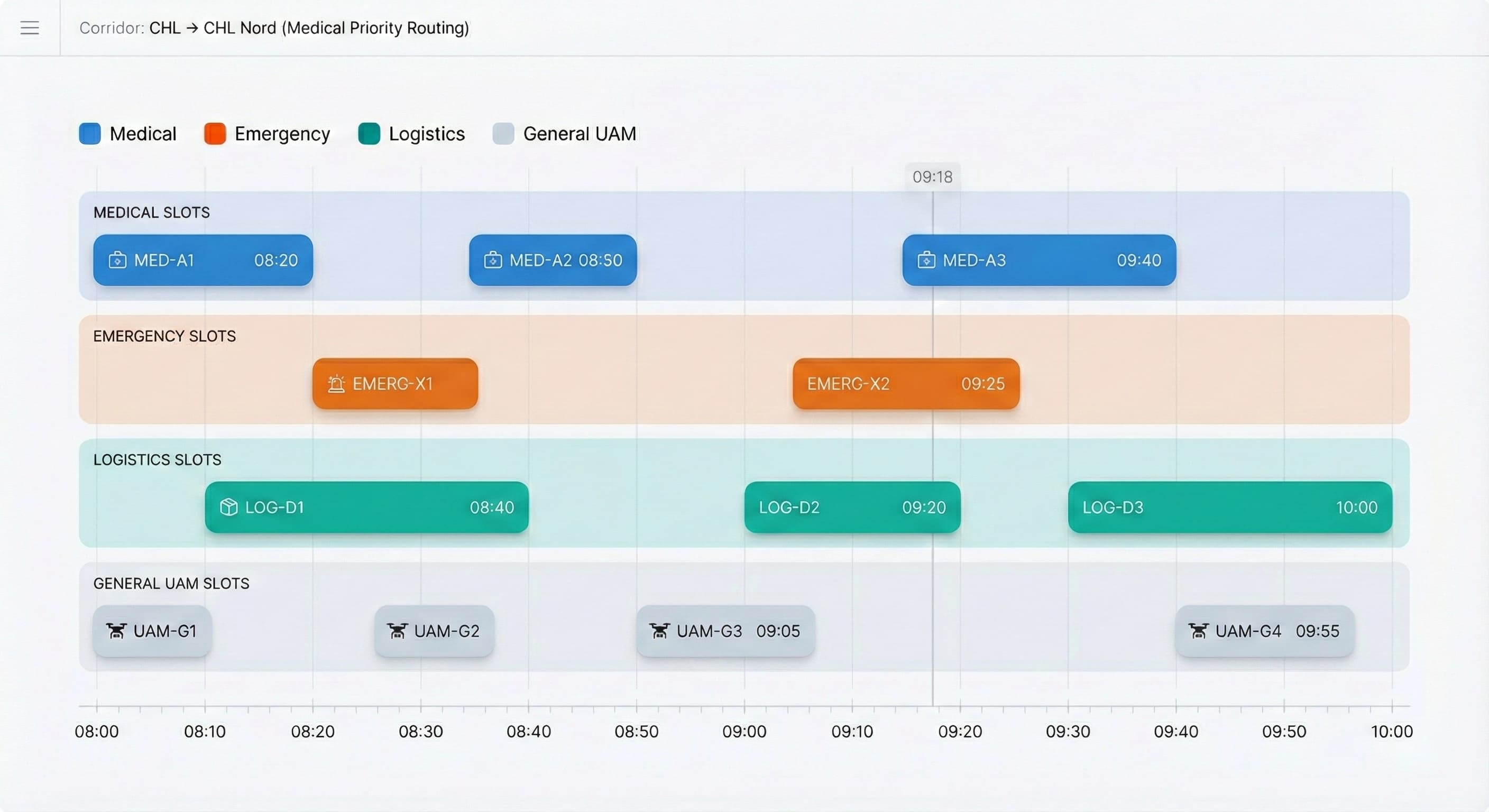
Active corridor operations – sample CorridorOS view
Use case: Luxembourg ⇄ Ettelbruck medical corridor
The Luxembourg ⇄ Ettelbruck medical corridor illustrates how structured low-altitude governance can support public services while managing safety and compliance. CorridorOS models the route, records constraints, and coordinates the information needed by relevant stakeholders.
Key capabilities
- • Corridor definition with altitude bands, buffers, and exclusion zones consistent with local and national constraints.
- • Structured slot allocation for time-critical missions within corridor capacity limits.
- • Corridors governed by clear noise envelopes and ESG constraints, documented for later review.
- • Integration points for existing hospital dispatch workflows and U-space services.
- • Compliance-grade logging so authorities and operators can reconstruct decisions and operations.
Outcome
Faster, more predictable critical-care transfers within a clearly governed corridor footprint that competent authorities, cities, hospitals, and operators can all understand and review.
How CorridorOS works
CorridorOS operates as a pre-tactical information and policy layer. It does not issue flight authorizations or replace U-space/ATM services. Instead, it provides structured corridor and policy data that competent authorities, ANSPs, USSPs, and cities can use to support safe and compliant operations.
Core building blocks:
- • Corridor Planner – define low-altitude corridors with altitude bands, required buffers, exclusion zones, allowable times, and corridors governed by documented noise and ESG constraints.
- • Slot & Capacity Manager – describe how corridor capacity is allocated for different mission types and time periods, including rules for protected access windows and quiet hours.
- • Policy Engine – translate municipal rules, hospital requirements, and applicable national guidance into machine-readable formats fully traceable to EASA/U-space standards.
- • Corridor APIs – USSPs, operators, and flight-planning systems retrieve corridor definitions, slot allocations, and applicable policies in real time, reducing ambiguity and duplication of inputs.
- • Audit & Compliance Layer – regulator-grade logging, policy version history, and corridor approval workflows, enabling authorities to reconstruct how constraints were set and applied.
CorridorOS operates as a neutral digital planning interface. It validates and standardizes data for Authority approval, ensuring city constraints are machine-readable for USSPs. It does not perform tactical conflict resolution or flight authorization.
Noise, safety, and policy modelling
CorridorOS helps authorities and cities model environmental, operational, and policy constraints before any flight takes place, supporting risk assessments and documentation.
Modelling inputs may include:
- • Terrain and elevation data
- • Population density and noise-sensitive areas
- • Municipal ESG and noise policies
- • Hospital transport requirements
- • Operator fleet characteristics (noise signatures, climb rates, max altitudes)
Outputs include:
- • Corridors governed by clear noise envelopes and ESG constraints, with transparent policy constraints
- • Altitude bands and safety buffers sized to local needs
- • Time-of-day operating limits
- • Scenario simulations for peak traffic and emergency overrides
Authorities receive a documented corridor footprint they can evaluate and explain; operators receive rules they can integrate into planning systems.
Slot operations: corridor capacity & timeline
Each corridor has a finite capacity per time interval. CorridorOS provides a way to describe how that capacity is allocated, within constraints set by authorities and cities, to support predictable and reviewable operations.
The slot timeline shows:
- • All upcoming flights in the corridor
- • Reserved windows for medical or critical operations
- • Quiet-hour protections
- • Congestion peaks and operator usage
- • Which corridor is selected (name, start/end points)
The timeline offers authorities, ANSPs, and cities a clear operational picture and a record that can be revisited in the context of safety oversight and performance review.
Security, privacy, and compliance
CorridorOS follows a modern, regulator-grade security model designed for public-sector and healthcare environments.
Platform principles:
- • Hosted in the EU
- • GDPR-aligned data handling
- • Support for regulator auditing and traceability
- • Immutable logs for corridor approvals and changes
- • Secure APIs with granular permissions
- • Option for air-gapped or private cloud deployments for hospitals and cities
The objective is to provide authorities and operators with the level of assurance expected for critical digital infrastructure.
How to deploy your first corridor
A structured, practical pathway for authorities, cities, hospitals, and operators.
- Discovery – review local noise policy, geography, dispatch workflows, ESG constraints, and expected traffic patterns.
- Corridor co-design – define altitudes, buffers, noise envelopes, slots, and permitted mission types, collaboratively with authorities, cities, and hospitals.
- Technical integration – connect CorridorOS APIs to existing U-space services, operator systems, or hospital dispatch tools.
- Validation & simulation – run scenario modelling for noise, congestion, and emergency cases.
- Launch & monitoring – enable live corridor operations with transparent rules, logs, and public-facing explanations where required.
Authorities retain oversight; cities receive a predictable governance framework; hospitals and operators gain clarity on how corridors are defined and controlled.
Roadmap
2025 · Pilot corridors
- • Luxembourg ⇄ Ettelbruck medical corridor
- • Co-design with city and regulator
- • Integration with initial U-space partners
2026 · Multi-city expansion
- • Additional corridors in EU urban regions
- • Deeper policy & noise tooling
- • Healthcare and emergency services playbooks
2027+ · Platform maturity
- • Standardised corridor and policy APIs
- • Advanced analytics & ESG reporting
- • Extended support for emerging U-space concepts
Talk to us about your first corridor
If you represent a civil aviation authority, ANSP, city, or hospital network, we would be happy to discuss how CorridorOS can support safe, compliant U-space deployment in your region.
Prefer email? Reach us at hello@amelia-aero.com.